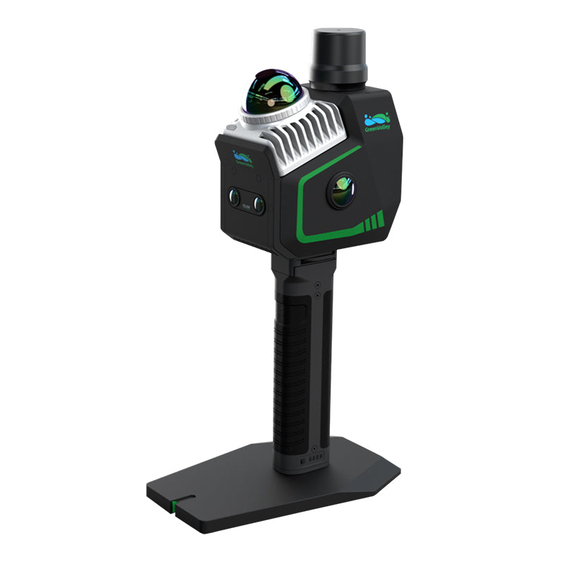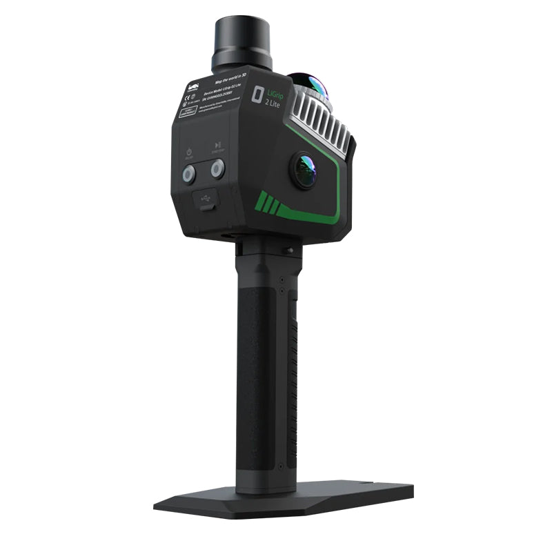


LiGrip H300 integrates multiple high-precision mapping methods, including SLAM, PPK-SLAM, and RTK-SLAM, allowing you to swiftly acquire point cloud data with absolute coordinates. Combined with LiDAR 360 and LiDAR 360MLS software, the LiGrip H300 can provide a one -stop solution on mapping, mining, forestry, road component survey and other scenarios.
- Scan Rate 640,000 pts/s
- Scan Range up to 300 m
- Laser Accuracy up to ± 1 cm
- Multi-Platform Compatibility
- Multiple Mapping Methods

SLAM
Point clouds with absolute coordinates can be obtained by bringing in GCP control points (if point clouds with absolute coordinates are not required, they can be directly collected).

RTK-SLAM
Suitable for areas with CORS signals, it allows you to directly obtain accurate point clouds with absolute coordinates.[In some regions, this feature is not available, please consult your local sales or partners for details]

PPK-SLAM
Point clouds with absolute coordinates can be obtained by bringing in GCP control points (if point clouds with absolute coordinates are not required, they can be directly collected).
300m ranging 640,000 pts/s

1-inch CMOS camera

Supports 6K images and high performs in indoor and low-light environments
Downloads
Kit Includes:
- LiGrip H300 Lite (with GNSS Module)
- Hard Carry Case
- Transfer Cable
- On-device Phone Mount
- LiDAR360MLS BP Module Perpetual Subscription (1x perpetual software license)
- This is enough to process the data from the proprietary format outputted by the device to generic pointcloud file formats, such as .las and .ply.
- Additional modules available. Please contact Laserman if you would like more information.
Warranty Terms & Extended Service Plans:
1. Standard Warranty:
- All hardware includes a 13-month standard warranty, starting from the shipping date.
2. Extended Service Plans - Basic & Premium:
LiAir, LiBackpack, LiGrip (excl. O1 Lite/O2 Lite), LiPod and LiMobile:
- +1 year Basic: 15% of price (+1,000 USD additional for Premium)
- +2 years Basic: 30% of price (+2,000 USD additional for Premium)
LiGrip O1 Lite/O2 Lite:
- +1 year Basic: 15% of price (+600 USD additional for Premium)
- +2 years Basic: 30% of price (+1,200 USD additional for Premium)
LiBase:
- +1 year Basic: 15% of price (+600 USD additional for Premium)
- +2 years Basic: 30% of price (+900 USD additional for Premium)
| Shipping | This Item Ships from Fremantle, Perth, Western Australia |
Please allow 2 - 10 days for your order to arrive.
Although Most Stocked Products will generally Ship Overnight. We source products from all over the world to bring you epic offers and the lowest prices. This means sometimes you have to wait a little longer to get your order but it's always worth it!
Returns are easy.
simply contact us for a returns number and send your item to our returns centre for fast processing. We'll get you a replacement or refund in a snap!
Description
LiGrip H300 integrates multiple high-precision mapping methods, including SLAM, PPK-SLAM, and RTK-SLAM, allowing you to swiftly acquire point cloud data with absolute coordinates. Combined with LiDAR 360 and LiDAR 360MLS software, the LiGrip H300 can provide a one -stop solution on mapping, mining, forestry, road component survey and other scenarios.
- Scan Rate 640,000 pts/s
- Scan Range up to 300 m
- Laser Accuracy up to ± 1 cm
- Multi-Platform Compatibility
- Multiple Mapping Methods
SLAM
Point clouds with absolute coordinates can be obtained by bringing in GCP control points (if point clouds with absolute coordinates are not required, they can be directly collected).
RTK-SLAM
Suitable for areas with CORS signals, it allows you to directly obtain accurate point clouds with absolute coordinates.[In some regions, this feature is not available, please consult your local sales or partners for details]
PPK-SLAM
Point clouds with absolute coordinates can be obtained by bringing in GCP control points (if point clouds with absolute coordinates are not required, they can be directly collected).
300m ranging 640,000 pts/s
1-inch CMOS camera
Supports 6K images and high performs in indoor and low-light environments
Downloads
Kit Includes:
- LiGrip H300 Lite (with GNSS Module)
- Hard Carry Case
- Transfer Cable
- On-device Phone Mount
- LiDAR360MLS BP Module Perpetual Subscription (1x perpetual software license)
- This is enough to process the data from the proprietary format outputted by the device to generic pointcloud file formats, such as .las and .ply.
- Additional modules available. Please contact Laserman if you would like more information.
Warranty Terms & Extended Service Plans:
1. Standard Warranty:
- All hardware includes a 13-month standard warranty, starting from the shipping date.
2. Extended Service Plans - Basic & Premium:
LiAir, LiBackpack, LiGrip (excl. O1 Lite/O2 Lite), LiPod and LiMobile:
- +1 year Basic: 15% of price (+1,000 USD additional for Premium)
- +2 years Basic: 30% of price (+2,000 USD additional for Premium)
LiGrip O1 Lite/O2 Lite:
- +1 year Basic: 15% of price (+600 USD additional for Premium)
- +2 years Basic: 30% of price (+1,200 USD additional for Premium)
LiBase:
- +1 year Basic: 15% of price (+600 USD additional for Premium)
- +2 years Basic: 30% of price (+900 USD additional for Premium)
Shipping
| Shipping | This item ships to |
Delivery & Returns
Please allow 2 - 10 days for your order to arrive.
Although Most Stocked Products will generally Ship Overnight. We source products from all over the world to bring you epic offers and the lowest prices. This means sometimes you have to wait a little longer to get your order but it's always worth it!
Returns are easy.
simply contact us for a returns number and send your item to our returns centre for fast processing. We'll get you a replacement or refund in a snap!
6 Great reasons to buy from us:
-

30 Days Return
If your product is faulty or damaged under manufacture warranty, simply send it back to us and we'll cheerfully replace it or fix the problem for you. -

Returns are Easy
Simply contact us for a returns number and send your item to our returns centre for fast processing. We'll get you a replacement or refund in a snap! -

Best Price Guarantee
In the unlikely event that you find your item cheaper at another online store, just let us know and we'll beat the competitor's pricing hands-down. -

We guarantee your satisfaction
We insist that you love everything you buy from us. If you're unhappy for any reason whatsoever, just let us know and we'll bend over backwards to make things right again. -

100% Safe & Secure
Ordering from Laserman Technologies is 100% safe and secure so you can rest easy. Your personal details are never shared, sold or rented to anyone either. -

Best Laser Warranties in the Business
Laserman the Best Laser Level, Pipe Laser and Laser Measuring Warranties in the Business - Now thats unbeatable value !!.